Welcome To Desertcart

You are browsing Tunisia's store.

We have a store for Us. Visit your country store to view the latest offers.

UK Counties Large Wall Map For Business (Laminated With Aluminium Frame & Metal Backing)
Thumbnail 1Thumbnail 2Thumbnail 3Thumbnail 4

UK Counties Large Wall Map For Business (Laminated With Aluminium Frame & Metal Backing)

Product ID: 150106392
Secure Transaction
Frequently Bought Together

Description

  • This map shows all the County, District and Unitary Authority boundaries within the United Kingdom.
  • Size: 120 x 83 cm (47 x 33 inches). Scale: 1:800 000 (12½ miles to 1 inch)
  • The recently published 2016 edition of the Counties map reflects the administrative changes that came into effect in April 2009.
  • Framed in satin-finish aluminium with a metal backing sheet, which makes this Map suitable for use with magnets.
  • Available laminated only, laminated and framed in either superb satin-finish aluminium (metal backing optional) or light, dark or black wood supplied ready to display.
  • ›See more product details

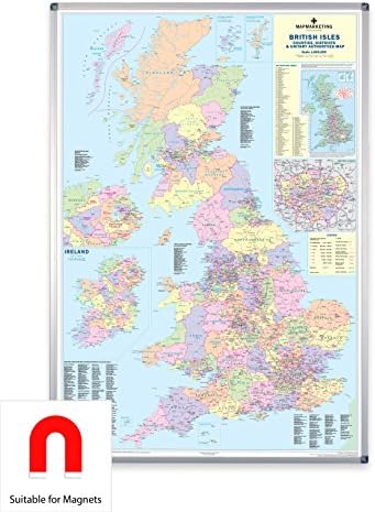
Colour Name:Laminated With Aluminium Frame & Magnetic Backing The recently published 2016 edition of the Counties map reflects the administrative changes that came into effect in April 2009. This map shows all the County, District and Unitary Authority boundaries within the United Kingdom. The divisions of each County into its local District Council areas are clearly shown. Each administrative area is shown in a different colour to its neighbours, making it easy to decipher where the boundaries lie. The map base shows motorways and primary roads (with more detailed roads on the London inset) and features seven types of town/city "stamps" based on population ranging from 2,000 to 1,000,000+ inhabitants.Inset is a smaller map showing all of the Postcode Area boundaries within the UK, with a list of these Areas giving their main postal towns. The inset map of London outlines the Borough boundary information. Also inset is a map of the whole of Ireland (Northern Ireland is also shown in full scale on the main map) with all County boundaries for the Republic. Population figures for all the regions shown on the map are given based on information supplied by the Local Government Commission and up-to-date as of 2014.Size: 120 x 83 cm (47 x 33 inches). Scale: 1:800 000 (12½ miles to 1 inch) This map is permanently bonded between two sheets of tough, flexible, crystal-clear plastic. This finish allows you to "write on, wipe off" with dry or wet wipe pens. This map is available laminated only, laminated and framed in either superb satin-finish aluminium (metal back optional) or light, dark or black wood supplied ready to display.

Common Questions

Trustpilot

TrustScore 4.5 | 7,300+ reviews

Sneha T.

Received my product in pristine condition. Great service overall.

1 month ago

Neha S.

Excellent communication throughout the order process. Product is perfect.

2 weeks ago

Shop Global, Save with Desertcart
Value for Money
Competitive prices on a vast range of products
Shop Globally
Serving millions of shoppers across more than 100 countries
Enhanced Protection
Trusted payment options loved by worldwide shoppers
Customer Assurance
Trusted payment options loved by worldwide shoppers.
Desertcart App
Shop on the go, anytime, anywhere.
1458.39 DT

Duties & taxes incl.

Tunisiastore
1
Free Shipping

with PRO Membership

Free Returns

30 daysfor PRO membership users

15 dayswithout membership

Secure Transaction

Trustpilot

TrustScore 4.5 | 7,300+ reviews

Vikram D.

The MOLLE sheath is of exceptional quality. Very happy with my purchase.

2 weeks ago

Anita G.

Good experience, but the tracking updates could be better.

2 months ago

Uk Counties Large Wall Map For Business Laminated With Aluminium | Desertcart Tunisia