
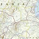


Tanzania, Rwanda, and Burundi Map (National Geographic Adventure Map, 3206)
Product ID: 1697391
Desertcart purchases this item on your behalf and handles shipping, customs, and support to Tunisia.
• Waterproof • Tear-Resistant • Travel Map Home to Mount Kilimanjaro and some of Africa's most popular safaris, Tanzania has bountiful opportunities for adventure travelers. Covering the region with unparalleled detail is National Geographic's Tanzania, Rwanda and Burundi Adventure Map. This expertly researched map combines topographical information, points of interest and a road network, making it the most comprehensive map available and the perfect compliment to any guidebook. The map's front side covers the western half of Tanzania and the entirety of Rwanda and Burundi, along with Lakes Victoria and Tanganyika, and Serengeti and Ruaha National Parks. While the reverse side covers the country's eastern half to its Indian Ocean shoreline as well as the islands of Mafia, Zanzibar and Pemba, the cities of Dar es Salaam and Dodoma, Selous Game Reserve, Ngorongoro Conservation Area and Kilimanjaro National Park. Find cities, towns and protected areas quickly with a user-friendly index. A mapped transportation network of major and secondary roads, tracks, border crossings, harbors, railway lines and ferry routes will help you get to your destination. Pinpointed on the map are national parks and reserves, kopjes, swamps, mangroves, areas of forest cover, scenic viewpoints, archeological sites, caves, churches, mosques, rock engravings, museums, hotels, lodges, campsites, beaches, diving areas, coral reefs and shipwrecks along with many other cultural, historical, ecological and adventure points of interest, including many hidden gems. Every Adventure map is printed on "Travel-Tough" waterproof, tear-resistant paper. Map Scale = 1:1,315,000 Sheet Size = 25.5" x 37.75" Folded Size = 4.25" x 9.25"

| Dimensions | 4.25 x 0.16 x 9.25 inches |
| Edition | 2022nd |
| Isbn 10 | 1566956196 |
| Isbn 13 | 978-1566956192 |
| Item Weight | 3.21 ounces |
| Language | English |
| Print Length | 2 pages |
| Publication Date | January 1, 2022 |
| Publisher | Natl Geographic Society Maps |
User
Great map!
Used it traveling and it was accurate and helpful!
User
excellent, 5 star seller
excellent product, great seller, fast delivery, fair price
User
Great quality
A strong quality map that has details of everything you'd want when travelling by road, or just figuring out where an airfield or train station are. Maybe not as good as a US type road atlas, but this will give a darn good idea of what's around and how to get there. With this particular map, Tanzania is the main focal point, with Rwanda and Burundi being little brothers. But, it still gives a good idea of both these other countries, and considering it's very hard to find a good map that has them on it in any detail, I'd highly recommend getting this. It's a map that will stay true for years to come.
User
easy to read map
Unfortunately, not your father's NatGeo map -- those were the days of great map-making. Alas, this is a road "travel map". I wanted a full-sized wall map. But these maps are half the country on each side of the map. The map emphasis is on roads/highways... again unfortunately. One would have expected a travel map to also emphasize railroad networks, but this one does not. It is slightly out-of-date in that it does not have the latest districts shown. But it is a handsome map. I bought two so that I can show the entire country when mounted on the wall.
User
Big and detailed
Really well done and durable
User
great Map for First Time Visitors
We took the map on our visit to Tanzania and Kenya last fall. If you are visiting the Masa Mara and the Serengeti, the map is a good source and information about where you are going on your trip.
User
Great Travel Maps
I bought the maps for my wife's planned safari next year. I love the sturdiness of the maps. We have used similar maps when exploring the western US by 4 Wheel Drive. They can survive a lot of abuse.
User
I travel all over the world and never go without ...
I travel all over the world and never go without one of these maps since they are durable and provide details not necessarily found in a travel book.
User
Ok.
Gut verarbeitet, wenig detailreich. Für grobplanungen ok.
User
Four Stars
Great map. Very sturdy.
User
Excellent
Just as described, thank you. Excellent quality and delivered in good packaging, on time. Couldn't have asked for more. Just great.
User
Good for travelling
Useful travel map that is waterproof. Bare in mind that there is half the country on each side so if you want a wall map, this won’t work.
User
Positive feedback
We're off to Tanzania for 3 months travelling around and hopefully this map will cover our needs. The scale is about as large as you can get and all details (towns, reserves, parks and borders) are clearly marked. The paper appears to be strong enough to withstand a fair amount of opening and closing before it (inevitably) disintegrates. 4* because it's printed on both sides which I dislike.
Trustpilot
4 days ago
3 weeks ago