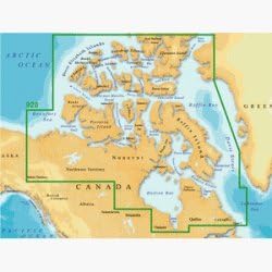
Magellan MapSend BlueNav XL3 Charts for eXplorist Northern Canada Salt/Freshwater Map microSD Card
Product ID: 389774041
🌊Tides & currents data
💾Pre-loaded microSD card
🗺️Extra-large detailed charts
🧭 Unlock Northern Canada’s waterways like a pro — don’t just explore, dominate!
The Magellan MapSend BlueNav XL3 Charts microSD card offers extra-large, Navionics Gold-based detailed maps for Northern Canada’s salt and freshwater navigation. Compatible with Magellan eXplorist 400, 500, 600, and XL GPS receivers, it provides real-time data on tides, currents, depth contours, and navaids, all in a lightweight, plug-and-play format designed to enhance your marine adventures.
| Product Dimensions | 20.32 x 2.54 x 15.24 cm; 22.68 g |
| Item model number | Northern Canada |
| Other display features | Wireless |
| Item Weight | 22.7 g |
T**Y
Magellan MapSend BlueNav XL3 Charts
It was impossible trying to verify the information for this product and it's compatibility with the Magellan products since I was receiving conflicting information from Magellan. I eventually ordered the item and when it arrived, it was not what was advertised. I received an SD Card and the item was advertised as a Micro SD Card. I soon discovered that the SD Card was blank and had no data on it. The only good thing I can say about this purchase is that Amazon quickly refunded my money.
Trustpilot
1 week ago
3 weeks ago