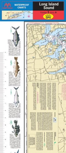
Complete coverage of Throgs Neck, NY to Block Island and Point Judith, RI
Featuring 160 GPS waypoints, courses, wreck sites, and ramp locations
36" x 48"
scale 1:89,000, with detailed Fishers Island Sound Inset, scale 1:40,000.
Maptech WPC001 Flip-Fold Waterproof Chart
Common Questions
Yes, all products are sourced directly from authorized retailers in the US, UK, UAE and India. We maintain strict quality control processes and verify each product before shipping. All items come with applicable manufacturer warranties and are covered by our standard return policy.
Delivery times vary by destination country, typically ranging from 3-9 business days. Each order is fully trackable through our system. We handle all customs clearance and use reliable courier partners for last-mile delivery. You'll receive regular updates about your order status via email and our app.
Desertcart is an international e-commerce platform operating since 2014. We securely process thousands of orders globally each day. Every product goes through our quality verification process before delivery, and we provide end-to-end order tracking, 24/7 customer support, and a comprehensive returns policy to ensure a safe shopping experience.
Our prices include the product cost, international shipping, import duties, customs clearance, and local delivery charges. We handle all customs and import procedures, ensuring there are no hidden fees upon delivery. PRO members receive additional benefits including free shipping.
Trustpilot
TrustScore 4.5 | 7,300+ reviews
Ravi S.
I loved the variety of products available. Will definitely shop again.
2 months ago
Zainab N.
Fantastic and great service. Shipping was faster than expected.